


ASHLAND CITY 2-C Voting District, Ashland County, Ohio
About
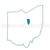
Outline

Summary
| Unique Area Identifier | 642588 |
| Name | ASHLAND CITY 2-C Voting District |
| County | Ashland County |
| State | Ohio |
| Area (square miles) | 0.63 |
| Land Area (square miles) | 0.62 |
| Water Area (square miles) | 0.01 |
| % of Land Area | 98.35 |
| % of Water Area | 1.65 |
| Latitude of the Internal Point | 40.87410870 |
| Longtitude of the Internal Point | -82.34193710 |
Maps


Graphs
Select a template below for downloading or customizing gragh for ASHLAND CITY 2-C Voting District, Ashland County, Ohio


Neighbors
Neighoring Voting District (by Name) Neighboring Voting District on the Map
- ASHLAND CITY 2-A Voting District, Ashland County, OH
- ASHLAND CITY 2-E Voting District, Ashland County, OH
- ASHLAND CITY 2-G Voting District, Ashland County, OH
- ASHLAND CITY 2-H Voting District, Ashland County, OH
- MILTON TWP #1 Voting District, Ashland County, OH
- MONTGOMERY TWP #2 Voting District, Ashland County, OH
Top 10 Neighboring County Subdivision (by Population) Neighboring County Subdivision on the Map
- Ashland city, Ashland County, OH (20,362)
- Montgomery township, Ashland County, OH (2,700)
- Milton township, Ashland County, OH (2,383)